Category infrastructure
DredgeFest Louisiana
Geographer Richard Campanella has evocatively described the Mississippi River—which is North America’s largest river, discharging more than three times as much water as the next largest river in the United States—as the “land-making machine”. And, indeed, historically, this is what the Mississippi River did: it made land, building its enormous delta—the southern half of the […]

Massively Redistributed in Space and Time
“If the earth were left alone [without human influence] on the order of eight cubic kilometers (10.5 billion cubic yards) of the material of the continents would be swept away by rivers into the ocean every year…By some estimates, about a third of this natural volume is prevented from reaching the oceans as a result […]

Migration of Landscapes
[Map of goose migration routes across North America, from Frank Bellrose’s definitive book on the subject: Ducks, Geese and Swans of North America] Migration is typically used to describe the physical movements of organisms. Accordingly, studies of migratory patterns tend to focus on the movements of birds, fish, butterflies, wolves and other biota. In vernacular […]

Singularity | Error | Spillover | Feedback
Anthropogenic Delta of Lake Mills Reservoir, Elwha River, Washington. Above: inset model on the left shows the valley’s topography as surveyed circa 1917 before the construction of Glines Canyon Dam. The model on the right shows topographic difference (in vertical feet) between the 1917 survey and 2010 LIDAR and Bathymetric survey data (Bureau of Reclamation), […]
Suites of New Elemental Landscapes
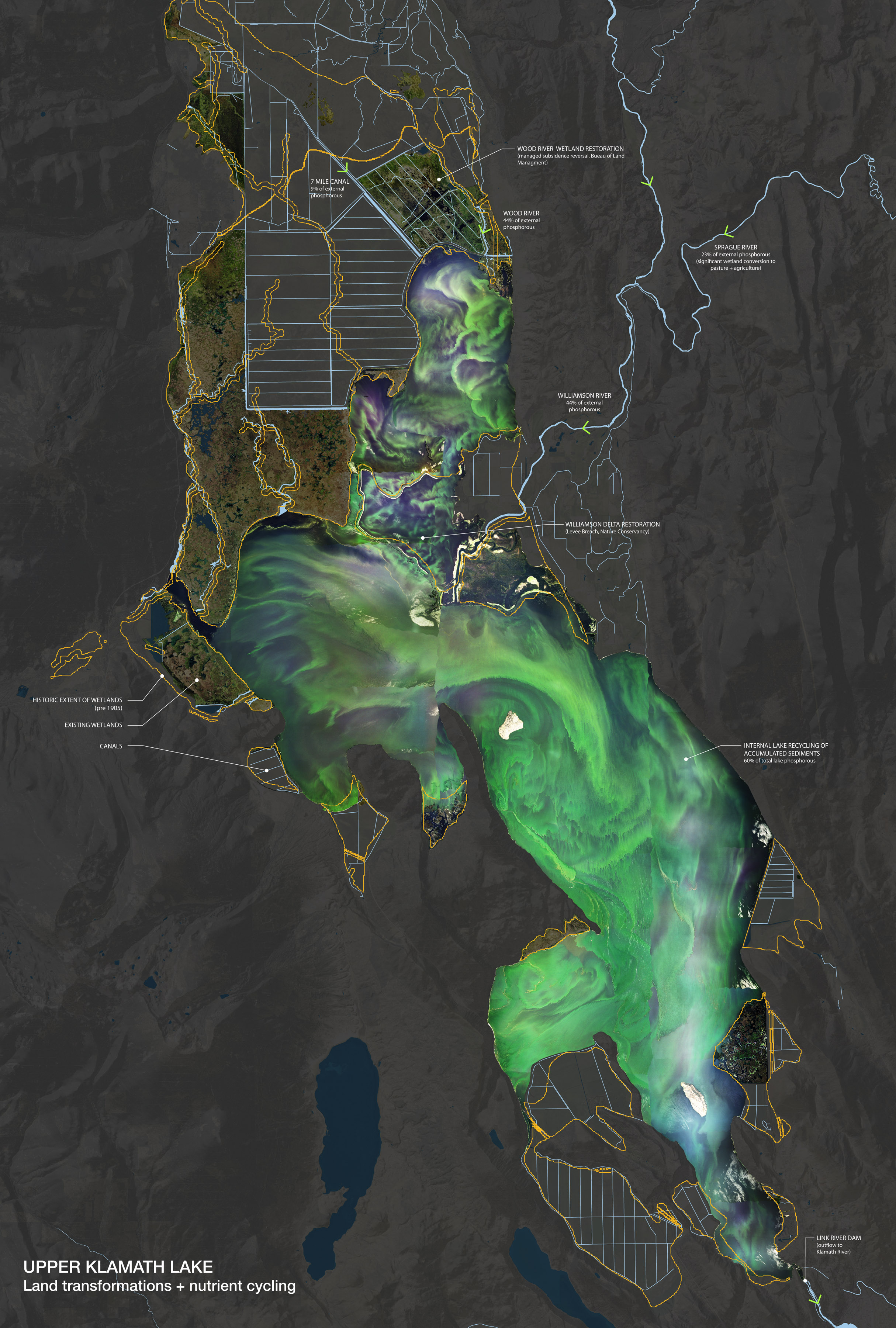
[Map of Upper Klamath Lake, Southern Oregon. The lake is approximately 80,000 acres in surface area and is seen here during a summer bloom of cynaobacteria called Aphanizomenon flos-aquae, or ‘AFA’. AFA feed upon copious amounts of phosphorous in the nutrient-laden water, caused in part by extensive landscape transformations and subsequent shifts in water flow […]

Future Baroque
The following piece was published last summer in La Tempestad; given that La Tempestad circulates primarily in Mexico and is published in Spanish, we — Rob Holmes and I, who co-authored the piece — thought that it would be worth re-publishing it on our respective sites for English-language audiences. The article builds on a pair of […]
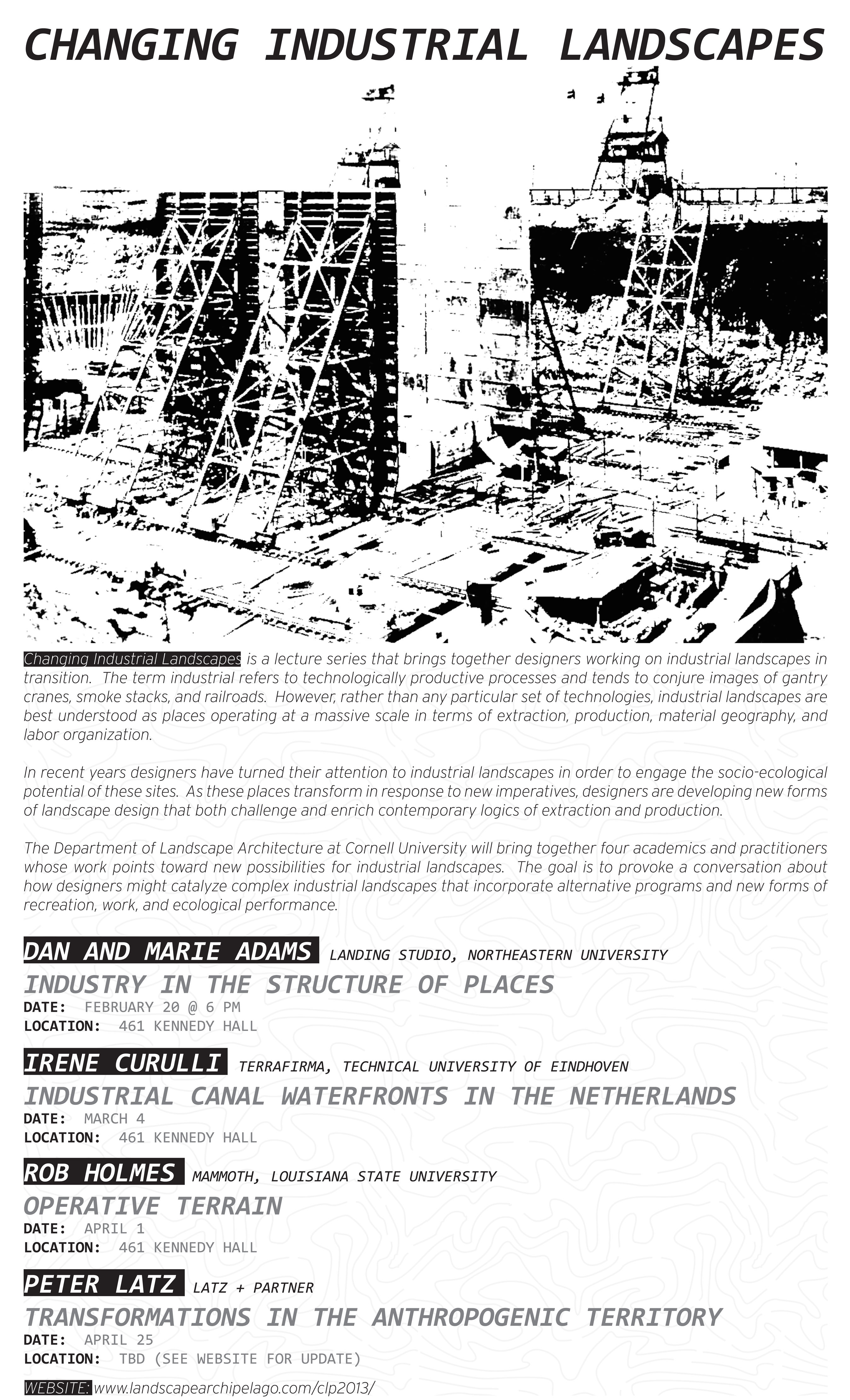
Changing Industrial Landscapes
A quick announcement for what looks like a promising lecture series at Cornell University: Updates, writeups and reviews of the series will be hosted at Brian Davis’ Landscape Archipelago

Soft Systems: Bracket 2
Located in the Chesapeake Bay, Poplar Island (above) is a flagship example of the USACE’s “beneficial uses of dredge”. Working with state and federal organizations, the USACE has been placing dredged sediments from The Port of Baltimore’s shipping channels onto the island since the mid-90’s. This practice meets the Port’s immediate need for a dredge […]

Making the Geologic Now
[Aerial view of Amwaj Island, Bahrain, where 2.79 million square meters have been reclaimed from the sea. The foundation of these islands and its surrounding breakwaters are made of geotubes, sausage-like casings of geotextile fabric that have been pumped full of 12 million cubic meters of dredged ocean sediments recycled from navigation channels and marinas. […]

Drifts in Magnetic Fields
[World Magnetic Model maps notating the magnetic field’s intensity (top) and inclination lines, or angle of the earth’s magnetic field above or below horizontal (bottom)] [Film of a suspension of dissociated cells from trout “olfactory epithelium” (cells extracted from some unfortunate trout’s nose) placed under the laboratory influence of a magnetic field rotating at a […]
